Peace

Peace
. . . in the valley

Saturday, September 10, 2016

1 Called to Visit BC's Peace River Country

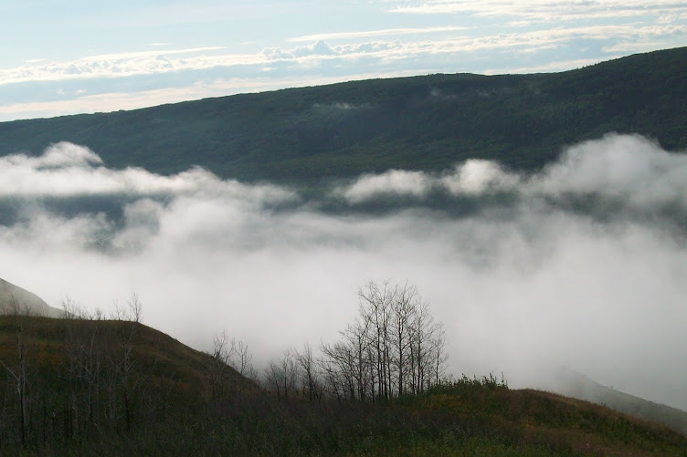
Clouds along the Peace, heavenly. 


1  Called to Visit BC's Peace River Country

From the Fort St John Lookout. Old Fort, the bridge at Taylor.
I was invited, and I felt I had to go. To cross the Rocky Mountains in the north, to see the Peace River and visit Peace River country.

The Peace River, 1900+ km long, flows east, from its Finlay River source in the BC Rockies, crossing the Alberta border east of the town of Pouce Coupe. East northeast across Alberta to the confluence with the Athabasca River, into the Slave River, and north into the Northwest Territories, to Great Slave Lake, the Mackenzie River, the Arctic Ocean. The Peace is an old river. It has carved a deep wide valley through the alluvial plain, the eastern foothills of the Rocky Mountains.

We drove northeast of Prince George, from west to east through the Pine Pass. To Dawson Creek. We crossed the river at Taylor and stayed in Fort Saint John. We visited on the Halfway River, a tributary. And headed back south, re-crossing the Peace near Hudson's Hope. Twenty-four hours of driving, 12 hours each way. We stopped in Quesnel one night there and back. A journey of 2700 km, from Hope to Halfway, plus 100 to get me from and back to home in Chilliwack.

I was called to see the majestic Peace River and its beautiful valley. Before it is gone. Or at least before more parts of it are gone. I felt called to witness.


2 Called to Witness a Crime

2  Called to witness a crime.

My Drive-by Shot of Peace Canyon Dam (from the bridge)

I felt called to witness a crime. A death. A death by drowning. The crime has not yet happened. But it will. It is scheduled, and each safeguard is being challenged, successfully or discouragingly, depending on your point of view. Safeguards supposedly there to protect both the environment and a democracy respectful of human and indigenous rights. Each hurdle has fallen, is falling, neatly, in order, into place. Clearcutting and infilling have already started. On Site C. The third phase.

From the Fort St John Lookout you can see that work has already begun.

In 1967, the W.A.C. Bennett Dam, 29 km west of Hudson's Hope, drowned forest and farmland under Williston Lake, a reservoir 250 km long and 150 km wide.
In 1980 the Peace Canyon Dam (pictured above), 6 km southwest of Hudson's Hope, drowned land beneath the 21 km long Dinosaur Lake reservoir.

Site C is just the third step in a 50+ year old plan. Site C, 7 km southwest of Fort St. John, will flood another 83 km of the Peace River Valley, plus 10 km of the Moberly and 14 km of the Halfway River.

3 An Eco-Crime

3  An Eco-Crime

Dinosaur Footprints were drowned under the first two dams.
A drowning is a death. This drowning death is a crime, perpetrated on others against their will, a form of murder. A death sentence for a landscape, a valley, a river, and a habitat - sheltering the living plants and animals therein. Not to mention geological and palaeontological features - drowned floodplains, drowned cliffs, drowned kettles, drowned dinosaur footprints, drowned fossils likely to have been able to re-write what we know of the history of the planet. A crime against the environment. Eco-cide. An eco-crime. The end of a way of life for some, and an anger-inducing disappointment for many more. A crime against humanity. A desecration that is both shameful and wrong.

4 Drowning Food-producing Land

4  Drowning food-producing land is wrong. 


There are many different ways that damming 100+ more km of the Peace River and its tributaries is wrong. For one, arable land is being flooded - destroying plant and animal life, impacting the lives of hundreds, thousands of British Columbia residents.. Food Security, our willingness and ability to feed ourselves, is being undermined. The provincial government took land out of the ALR (Agricultural Land Reserve) to clear the way for dam and reservoir. In August, 2015, a chairman of the Agricultural Land Commission, Richard Bullock, was fired in order to facilitate this reversal. Removing arable land from protection is a short-sighted self-serving decision which will have a negative impact on the future of the province. 

We seldom hear of the concerns of northern residents down in "the Lower Mainland," but all along the road I saw billboards protesting. 


I want to say "northern citizens" concerned about food security, but many must feel not like citizens who have the respect of fellow citizens and elected officials but rather as victims. Because their fellow citizens and elected officials, to the dismay of residents, plan to drown their valley and destroy the way they have chosen to live their lives, growing food for themselves and others. A crime against the human right to choose where to live and what work you will do. 

5 "Disappearing" Treaty 8 Land

5  "Disappearing" land and hunting territory reserved as a Treaty Right is wrong. 

"The Peace River is the lifeline for numerous First Nations - a critical pathway for their food security, cultural survival, and spiritual identity." (Leadnow.ca) It is wrong to "disappear" land upon which many people rely. In this region, many citizens including many First Nations live directly off the land, by hunting, gathering, and growing their own food. They will lose their homes and/or territory upon which they rely for physical, cultural, spiritual sustenance. 


Destroying land which has been guaranteed to them by aboriginal right in the Canadian Charter of Rights and Freedoms and by treaty, Treaty 8, is a crime on so many levels. The United Nations Declaration on the Rights of Indigenous Peoples states that self-determination includes the right to freely pursue "economic, social and cultural development" and refers to dispossession, relocation, archaeological and historical sites, consultation and cooperation in good faith, distinctive spiritual relationship with lands & waters, the right to own, use, develop and control the lands and resources, conservation and protection of the environment and the productive capacity of their lands, and the recognition, observance and enforcement of treaties. As well as prompt resolution of conflicts. Is there any wonder why Canada has been slow to ratify this declaration?

The Peace River was named to commemorate a peace treaty signed in 1781 between the Danezaa (Beaver) and the Cree Indians who inhabit the watershed. Later, before settlers arrived, First Nations of the area including Woodland Cree, Danezaa, and Chipewyan, signed Treaty 8 with Canada in 1899, agreeing to share territory, to accept reserve land, land entitlements, financial and material support, guaranteed hunting rights, and provisions to maintain livelihood in a territory large enough to enable them to live their culture. "This is land we rely on to hunt, fish, and hold ceremonies. Our ancestors are buried here." (Cited by Amnesty International.) The Federal government representing all Canadians has an obligation to respect the treaty - a nation-to-nation contract.

Since the build-up to Site C, local First Nations bands have participated in the environmental assessment and hearings process. Three bands have initiated court challenges - the Prophet River First Nation, the West Moberly First Nation, the Blueberry River First Nation, as well as Treaty 8 First Nations in both British Columbia and Alberta.

On September 12, 2016, the Federal Court of Appeal in Montreal will hear the latest legal challenge of Site C. A Treaty 8 Justice for the Peace Caravan is travelling across Canada by bus to focus attention on this case and the larger issues involved. Follow them at nosite-c.com and JusticeForThePeaceCaravan on Facebook.com.

Brody, Hugh. Maps and Dreams: Indians and the British Columbia Frontier. Douglas & McIntyre, 1981. Thirty-five years ago, Hugh Brody researched the clash of cultures between the Indians of this region and the oil and gas interests preparing the way for a pipeline. Brody lived with the Beaver Indians (Danezaa) north and west of Fort St John, on the Halfway and Moberly Rivers, in an attempt to learn and document the peoples' understanding of the land and their connection to it. His presentation balances both views, but in his conclusion, "A Possible Future," he comments: "Great fortunes are to be made, from construction and speculation . . . development . . . progress . . . [Talk of] national expansion [is] . . . a brightly coloured smokescreen behind which minority rights, local needs, economic interests of the majority, and destruction of the land itself have all been conveniently concealed. Future generations will wonder at the dominance of the few and the gullibility of the many." [p. 181]


Lutz, John Sutton. Makuk: A New History of Aboriginal-White Relations. UBC Press, 2008. ". . . there is not yet a will among non-Aboriginal Canadians to listen across the boundaries that so clearly exist, to hear alternative ideas. Racism has not gone away." [p. 298]


6 "Disappearing" Rural Homes

6  "Disappearing" land bought and maintained as a chosen rural lifestyle is wrong. 

Land along the Halfway River, closer to the Peace than here, will also be flooded. 

Many others, not only First Nations, live close to / on the land. Those who have chosen to live within the beauty and abundance of a rural setting will also be losers, forced by the decisions of others to abandon an outdoor lifestyle for something less desirable. It is the imposition, the being forced to change by decisions made by others, of having your voices unheard or ignored, the sense of having no control, of impotence, which is both so frustrating and so disheartening. Discouraging, because such disrespect should not be acceptable. It fails to comply with ideals of human rights - respect for the inherent dignity of the individual, our right to own property, to freely choose our work and lifestyle. The right not to have homes subjected to arbitrary interference by the State, not to be deprived of property, not to have our ability to participate in the cultural life of the community curtailed. 

Waiting for the Mother & Calf Beauty Contest at the fall fair.

7 Deliberate Blindness

7  BC's willingness to sacrifice the Peace reflects deliberate self-serving blindness. 


BC is willing to sacrifice the Peace because it is "out of sight, out of mind." Because of distance (our 3000 km staycation?), the region is far from the BC centres of power and population. Most British Columbians will never have seen Peace River country. It is just there, on the other side of the mountains, in territory that seems more logically to belong to a prairie province, if mountain peaks and river watersheds were used to determine boundaries. 

Near Fort St John, BC
No one in BC feels responsible for environmental degradation, water shortages and water quality issues, downriver, in a neighbouring province or territory. We never even hear of the damage done farther east, by our interference with the river's flow. In the same way that we never hear the voices or the opinions of the BC residents in Peace River country. Not enough people care. It is BC hinterland, ripe for exploitation, there to service the rest of us.